Ship Speed Watch
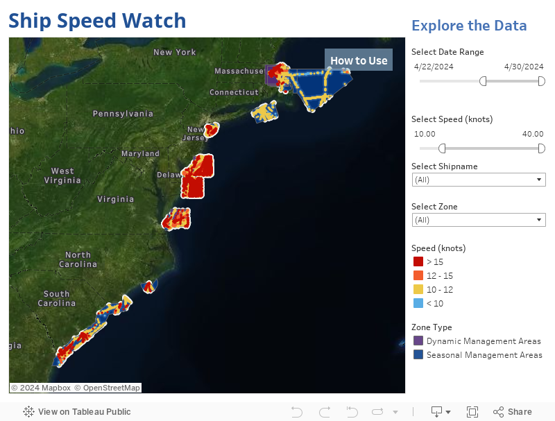
Oceana’s “Ship Speed Watch” allows users to monitor ship speeds in voluntary and mandatory speed restricted zones that were established to protect marine mammals like North Atlantic right whales along the East Coast of Canada and the United States in near real-time. When mandatory and enforced, speed restriction zones can help prevent collisions with ships, one of two leading causes of North Atlantic right whale injury and death. Ship Speed Watch was created using Automatic Identification System (AIS) data from Global Fishing Watch, an independent non-profit founded by Oceana in partnership with Google and SkyTruth, which uses cutting-edge technology to interpret data from various ship tracking resources. AIS was initially designed as a safety mechanism for ships to avoid collisions at sea. Using ship identifying information reported by operators, AIS can be used to monitor and track ship movements over time since it transmits a ship’s identity, speed, and GPS location.
NOTE: If the map is not loading properly try clearing your browser data
Background
Ship Speed Watch uses vessel information in the Global Fishing Watch database. This information is transmitted from a vessel’s Automatic Identification System (AIS) device, which is collected via satellites and terrestrial receivers. Faulty AIS devices, user error, intentional manipulation, crowded areas, poor satellite reception, and transmission flaws are factors that contribute to noise and errors in AIS data, and sometimes those inaccuracies can be reflected in the speed and location of a vessel. Vessel operators can accidentally or purposefully enter false information into their ship’s AIS thus concealing their identity or location. In crowded areas, such as ports, the massive number of radio transmissions can crowd the bandwidth of satellite and terrestrial receivers, leading to inaccuracies as well. For these reasons, Ship Speed Watch information must be relied upon solely at your own risk.
In 2019, Oceana launched a campaign in the U.S. and Canada to help save the North Atlantic right whale, one of the most endangered large whales on the planet. They were named for being the “right” whale to hunt because they were often found near shore, swim slowly, and tend to float when killed. North Atlantic right whale populations first crashed due to whaling until hunting this species was banned in 1935. Now the whales are on the brink of extinction mostly due to threats from marine vessel traffic and commercial fishing. Today, only about 330 North Atlantic right whales remain, including fewer than 80 breeding females, and the loss of even one animal a year is biologically devastating to the species’ recovery. They could be the first large whale species to go extinct in the Atlantic Ocean in centuries. To reverse course, North Atlantic right whales must be protected from ship strikes and fishing gear entanglements.
North Atlantic right whales are slow, swimming around six miles per hour, usually near the water’s surface. They are also dark in color and lack a dorsal fin, making them very difficult to spot. At normal operating speeds, ships cannot maneuver to avoid North Atlantic right whales, putting the whales at great risk of strikes, which can cause deadly injuries from blunt force trauma or cuts from the propellers. Slowing ship speeds to 10 knots or less in areas where these whales may be encountered can reduce death from collisions by 86%.
A 2020 Oceana analysis of ship speeds in an area south of Nantucket found that 41% of ships were ignoring the voluntary speed limit of 10 knots, which was established by the National Oceanographic and Atmospheric Administration (NOAA) to reduce the risk of injury or death to these whales. Oceana Canada also released a report with an analysis indicating that 67% of ships were ignoring a voluntary speed zone in the Cabot Strait designed to protect this species. Requiring ships to slow down can help save North Atlantic right whales from extinction.
To learn more about Oceana’s binational campaign to save North Atlantic right whales, click here.
To make your voice heard and tell government officials to act now to protect North Atlantic right whales, click here.
To learn more about speed restriction zones in the U.S. click here and in Canada click here.
To read the methodology of how this map was developed, click here.