Report | February, 2014
Oceana proposal for Marine Protected Areas
Several scientific studies provide proof of the successes of Marine Protected Areas (MPAs) in enhancing biodiversity and benefiting sea life. MPAs provide threatened species and living breeding grounds a place to rebuild and flourish. For example, areas facing reduced pressure, where fisheries have been banned or restricted, have healthier communities and often host fish that are significantly bigger and more plentiful than in the areas outside reserves. As fish get bigger in a protected area, productivity increases and creates a spillover effect (of larvae and fish) into surrounding areas leading to bigger catches in these neighboring areas. But the areas set aside need to be large enough to minimize human caused stress factors as much as possible. Another important thing is also to protect different kinds of marine environment. Most the protected sites in the Baltic Sea today is coastal areas, but deep areas are equally important.
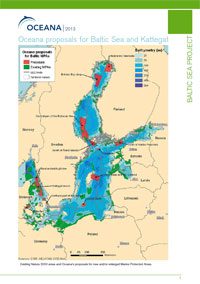
Based on three expeditions in the Baltic Sea and the Kattegat, both in shallow and deep waters, Oceana has put together 13 comprehensive conservation proposals for ecologically important areas. Click on each name to learn more about that specific location.

IntroductionSeveral scientific studies provide proof of the successes of Marine Protected Areas (MPAs) in enhancing biodiversity and benefiting sea life. MPAs provide threatened species and living breeding grounds a place to rebuild and flourish. For example, areas facing reduced pressure, where fisheries have been banned or restricted, have healthier communities and often host fish that are significantly bigger and more plentiful than in the areas outside reserves. As fish get bigger in a protected area, productivity increases and creates a spillover effect (of larvae and fish) into surrounding areas leading to bigger catches in these neighboring areas. But the areas set aside need to be large enough to minimize human caused stress factors as much as possible. Another important thing is also to protect different kinds of marine environment. Most the protected sites in the Baltic Sea today is coastal areas, but deep areas are equally important. Based on three expeditions in the Baltic Sea and the Kattegat, both in shallow and deep waters, Oceana has put together 13 comprehensive conservation proposals for ecologically important areas. Click on each name to learn more about that specific location. Download (PDF) |
|

Ulkokrunni and MerikallaThe two areas, Ulkokrunni and Merikalla, are situated in the Finnish EEZ, in the northern part of the Baltic Sea, the Bothian Bay. The Bothnian Bay is characterized by having a low salinity of 3.5 psu, which limits the number of marine species living there (Bergström and Bergström 1999) and freshwater species are more common. During winter the bay has at least four months of ice, which also affects which species can live there. The Ulkokrunni area consists of small scattered islands and primarily shallow waters. However, deeper areas down to almost 100 meter also exist. Merikalla is a shallow area situated almost 20 km west of the island Hailuoto, and south of Ulkokrunni. In the spring of 2011, Oceana conducted research in the area of Ulkokrunni, and in the spring of 2012, a more comprehensive research was carried out in the area of Ulkokrunni. Additionally Merikalla was also carefully studied by an ROV (Remotely Operated Vehicle). Download (PDF) |

South of Åland IslandsThe autonomous region of the Åland Islands, which is made up of more than 6,500 islands, forms part of the Archipelago Sea. It is situated between Finland and Sweden at the entrance to the Gulf of Bothnia. The coastal area has a complex topography, with many small islands and skerries, and experiences up to 90 ice days during the winter. The seabed in the region is characterized mainly by hard bottoms, including boulders and stones, but patches of sand occur as well. In deeper waters, mud dominates the seabed. Physical factors, like water temperature, dissolved oxygen saturation and the organic content of sediment, control benthic life in the area. Some marine protected areas, including Natura 2000 areas and a Ramsar (The Convention on Wetlands) site called Signilsär-Märket Archipelago, exist in the Åland region, but the offshore waters in particular, lack protection. Oceana conducted underwater surveys with an underwater robot (ROV) and scuba dives, at different depths from the coast to offshore waters in the area south of the Åland Islands in 2011, 2012 and 2013. Download (PDF) |

BogskärBogskär is a small group of islets, located 60 kilometers from the nearest coast in the middle of the Baltic Sea, between Finland and Sweden. It is the southernmost point of Finland. The main skerry holds a small automatic lighthouse with a helicopter landing pad. The offshore islets are home to a colony of grey seals (Halichoerus grypus) which is currently listed as a protected species under Annex II and Annex V of the European Habitats Directive. In the spring 2012, Oceana conducted underwater research in the area near Bogskär, both in shallow waters next to the main island, and in the deeper waters some kilometers from the islands. Download (PDF) |

South of Hanko PeninsulaHanko Peninsula, located at the entrance to the Gulf of Finland, is the southern-most part of the Finnish mainland and boasts an archipelago and long sandy beaches. Salinity is relatively low, ranging from 5.5 to 7.5 psu, and the waters in the shallower coastal areas are limnic. Upwellings, a common occurrence in the area wherein nutrient-rich sediments are brought up to the surface, cause a rapid increase in the salinity in areas at 35 meters, and a small increase in salinity in the surface water. The inner waters of the archipelago freeze every year, while the more open waters freeze regularly, but not every winter. Parts of the coastal area are protected under EU Natura 2000 network, and the area is classified as a sea area requiring specific protection measures. Wetland areas are also included in the Ramsar network. Because of the special characteristics of the area (changing salinity, archipelagos, wetlands), there are a lot of different zones that are able to host a wide variety of different species and communities. Oceana conducted in the spring of 2011 and 2012 information from the area with ROV (Remotely Operated Vehicle), bottom samples and scuba dives. Download (PDF) |

The SoundThe Sound is located between Sweden and Denmark, and forms, together with Little Belt and Great Belt, a connection between the brackish Baltic Sea and the saltier North Sea via Kattegat and Skagerrak. The layering of the water column is strong. The outflowing water from the Baltic Sea towards Kattegat has a low salinity at 10 psu, putting the relatively lighter water at the surface. The saltier water from Kattegat, at 20 psu, is heavier and runs to the Baltic Sea in a south-going bottom stream. A transverse threshold, called Limhamn/Drogden, which is found at less than 10 meters deep at the narrow part in the south of the Sound, acts as a barrier to water exchange between the Baltic Sea and Kattegat. In 1932, a bottom trawling ban was established in the Sound because of the heavy traffic in the narrow strait. The ban, which is still in effect, is one of the main reasons behind the number of rare and diverse benthic communities found in the area today. Currently, there are a number of small coastal Natura 2000 sites and other small protected areas in the Sound, but the northern part, which in particular has many unique habitats, remains mostly unprotected. Download (PDF) |

Bothnian Bay DeepThe Bothnian Bay is located in the northernmost part of the Baltic Sea, with an average depth of 40 meters and its deepest point reaching further than 100 meters. An archipelago, consisting mainly of sand and gravel islands lies in the north, while the south of the bay boasts a rocky coast and bedrocks. Relatively rapid land upheaval, of approximately 9 mm a year, occurs particularly on the Finnish side of the bay. The Bothnian Bay is frozen on average 170 to 190 days a year and large freshwater rivers run into it, keeping salinity low, at around 3.5 psu. The Bothnian Bay is in a relatively healthy status, as it is not suffering from eutrophication, and has good oxygen levels even in the deeper areas, unlike most of the Baltic Sea, where anoxic bottoms are common due to eutrophication. Oceana studied the deeper parts of the Bothnian Sea in 2011 and 2012 using an ROV (Remote Operating Vehicle). Download (PDF) |

Central part of the Bothnian SeaThe Bothnian Sea is the southern part of the Gulf of Bothnia, and connects the northern most part of the Baltic Sea, the Bothnian Bay to the Baltic Proper. The Gulf of Bothnia, which covers an area of approximately 65,000 km², is shared between Sweden and Finland, ending in the waters of the Åland Islands in the south. Salinity in the Gulf props from around 6 psu in the southern parts, to 5 psu in the north. The stratification is not as strong as in the Baltic Proper and the water masses get mixed during autumn and winter preventing the formation of oxygen poor bottoms. Also the nutrient load is smaller in the Bothnian Sea. The mean depth of the Bothnian Sea is 60 meters, and the basin freezes over annually during the winter months. The coast is characterized by small archipelagos and rocky shores, at the sea bottom hard bottoms dominate, but there is also some soft sediment in deeper areas. Oceana conducted nine underwater surveys, using an underwater robot (ROV) and scuba divers, in both offshore and coastal areas of the Central part of the Bothnian Sea in 2011. Download (PDF) |

Marstrand and Northeastern KattegatMarstrand, located in the southern Bohuslän Archipelago, is situated in the northeastern part of the Kattegat, on Sweden’s west coast. The Kattegat and the neighboring Skagerrak form the transitional area between the salty North Sea and the brackish Baltic Sea. The Kattegat is fairly shallow with a mean depth of only 23 meters, but its deeper areas, including the Kattegat and Djupa Rännan trenches can reach more than 150 meters. The latter is connected to the former, which runs 45 km south through mainly Danish waters. The surface salinity in northern Kattegat is relatively salty (30 psu) when compared to the southern part (15 psu). Water in deeper areas is even saltier, as the salty water from the North Sea and the Skagerrak flows towards the Baltic Sea via the lower layers of the water column. The upper layer transports water from the Baltic Sea to the Skagerrak and North Sea. As there are almost no tides in the Skagerrak and Kattegat, the major movements of water between the North Sea and the Baltic Sea occur through wind power. Oceana conducted underwater studies with an underwater robot (ROV) and scuba divers in the area 2011, 2012 and 2013. Download (PDF) |

Kattegat trenchKattegat is in the transition zone and the main gateway between the North Sea and the Baltic Sea through which the salty water of the former and the brackish water of the latter flow. The deep trench, located in the central part of Kattegat, spans 45 km from the northeast of Læsø towards the southeast, and boasts reefs and bubbling reefs. The deepest part of the trench is 151 meters down and the surrounding areas range from 20 to 40 meters deep. As salinity is remarkably higher in Kattegat than in the inner Baltic Sea, marine species are able to thrive and biodiversity is higher. In the deeper parts of Kattegat up to six times as many benthic species were found in a bottom sample compared to one from the inner Baltic Sea. Oceana conducted surveys in this area in 2011 and 2012. Download (PDF) |

Little BeltDenmark’s Little Belt is a marine strait located between the Jutland mainland and the island of Fyn. The Little Belt and the Great Belt together make up the Belt Sea, which along with the Sound forms the transition zone between the saltier Kattegat and the brackish Baltic Sea. Approximately 10 % of the water exchange between the Baltic Sea and Kattegat flows through the Little Belt. Its depth varies from shallow lagoons, inlets and bays, to deeper trenches averaging 35 meters, with its deepest point, “Marens Hul,” at 81 meters, which is located west of Fænø. Islands and peninsulas can also be found in the area. A relatively large Natura 2000 site exists in the southern part of Little Belt, but a narrow area in the north of the Belt remains unprotected. Even further north, at the border to Kattegat, there are two additional Natura 2000 sites. One of them, the island of Æbelø, is a conservation area where one can find various reefs, including a diverse stone reef north of the island. Little Belt and the area north of it also contains RAMSAR sites (wetlands which are of international importance) and a big population of harbour porpoises. Little Belt is also an internationally important area for water birds, as it is used for breeding, wintering and staging by ducks, geese and cormorants. Oceana conducted fieldwork in the Little Belt area in 2012 and 2013, with the use of an underwater robot, and scuba divers. Download (PDF) |

Middle BankMiddle Bank is located in the middle of the southern Baltic Proper, the main basin of the Baltic Sea. Salinity in the sub basin varies from higher levels in the southern and western parts to lower levels in the north, where the number of marine species declines. The Baltic Proper boasts a number of important breeding grounds for fish, birds and seals, but its overall health is poor, as a consequence of the excessive nutrient load that has led to eutrophication. Oceana conducted underwater surveys in the area in 2011 and 2012. Download (PDF) |

The QuarkThe Quark is a transnational area between Finland and Sweden, the majority of which lies in the former, that is dotted with 5600 islands. The Quark displays some unique biological conditions because of the rapid land uplift, a geological phenomenon caused by the last ice age. The annual uplift is one of the fastest in the world and greatly shapes the geology and biology of the area. The Quark is included in the World Heritage List of UNESCO because of its unique geological features. The Quark forms a shelf creating a transition zone between two sub-basins, the Bothnian Bay and the Bothnian Sea, and limiting water exchange. These conditions create differences in salinity in these sub-basins, which affect species composition in the Quark. Some marine species reach their northern distribution limit precisely at the Quark. The sea bottom is characterized by bedrock and rocks ranging in size from pebbles to big boulders, but patches of sand do occur. The Quark and the area south of it include a number of small marine protected areas, both in Finnish and Swedish waters. As far north as it is, the ice season in Quark lasts from around 120 days from January to April in the outer coastal parts of the Quark, to around 150 days in the inshore areas. The Gulf of Bothnia is less exposed to nutrient leaching than the rest of the Baltic Sea, as fewer people are living in the catchment area. Oceana conducted fieldwork in the southern part of the Quark in 2011 and 2013, with the use of an underwater robot (ROV), scuba divers and bottom samples. Download (PDF) |